Student Reviews of Traffic Calming and Bike-Pedestrian Treatments in the Boston area. Northeastern University, CIVE 5376 "Traffic Engineering", Instructor = Peter Furth
Tuesday, April 24, 2012
Neighborhood Traffic Circles - Intersection of South Street and Intervale Road in Brookline, MA
By Patrick Lupfer
What is a Neighborhood Traffic Circle?
A neighborhood traffic circle, or traffic-calming circle, is an unsignalized intersection
treatment in which traffic flows in a circular, counterclockwise pattern. Traffic circles are typically found along local streets in
residential neighborhoods where low traffic volumes and low travel speeds exist [FIGURE 1].
Traffic is encouraged to circulate around a raised central island with a diameter between 10 and 25 feet.
The central island is often landscaped to increase the aesthetic appeal
of the traffic circle, and this landscaping may be maintained by local residents or by the
local municipality [FIGURE 2].
FIGURE 1 Typical Neighborhood Traffic Circle (http://www.ite.org)
FIGURE 2 Neighborhood Traffic Circle with Landscaping in Vancouver, Canada (http://www.cstreetne.blogspot.com)
The presence of the central island
prevents motorists from making direct left-turns and instead requires them to
travel in the circular flow pattern until they reach their desired exit
point. Signage that requires
motorists to stop or yield is present at the entry points to the
intersection, and serves as the primary traffic control measure for vehicles. Traffic
circles are not typically used at intersections that experience high volumes of
heavy vehicles (trucks, buses, etc.) turning left due to the restricted turning
radius of the intersection.
The success of the neighborhood traffic circles can be accredited
to several reasons, however the characteristic that is most influential
in this
success is the decrease in the number of conflict points. A conflict
point is a specific location
in an intersection where traffic crosses paths and a collision can
occur. A traditional two-lane,
four-leg intersection presents 32 vehicle-to-vehicle conflict points,
whereas a neighborhood traffic circle, or a two-way roundabout, reduces this number to 8 [FIGURE 3]
[FIGURE 4]. This reduction in the
number of conflict points correlates to fewer collisions and therefore
fewer
injuries. The traffic circle also results in less severe collisions when they do occur.
This is due to the decreased speed of
motorists within the intersection and the smaller angle at which
collisions
occur. The majority of collisions
within neighborhood traffic circles are sideswipes and rear-end collisions,
which are
far less severe than perpendicular or “t-bone” collisions. The Institute of Transportation
Engineers (ITE) states that neighborhood traffic circles have been found to
reduce midblock speed by up to 10% and intersection collisions by up to
70%. This contributes to creating
an overall safer living and traveling environment for all users in the residential
area.
FIGURE 3 Traditional Intersection Conflict Points (http://www.wcroads.com)
FIGURE 4 - Modern Day Roundabout Conflict Points (http://www.wcroads.com)
Some disadvantages to the installation of neighborhood
traffic circles do exist, however the affected users are not the majority of
those traversing the intersection.
Heavy and emergency vehicles often experience difficulty in making left
turns through the intersection due to the necessity of a larger turning
radius. This sometimes results in
larger vehicles using the intersection incorrectly or encroaching on the raised
central island [FIGURE 5]. Studies
conducted by the ITE have found that emergency vehicles experience an
additional intersection delay of between 5 and 8 seconds per traffic circle.
FIGURE 5 Traffic Circle with Scraped Curb from Heavy Vehicle Traffic
What is the difference between a Neighborhood Traffic Circle and a Modern Day Roundabout?
A modern day roundabout is also a type of unsignalized intersection
treatment in which traffic flows in a circular pattern, however modern day roundabouts are much larger in size with central islands of 45 to 80-feet in diameter. The increased size and more channelized design of a modern day roundabout enables the intersection to handle higher volumes of traffic than a neighborhood traffic circle, as well as higher entry and circulatory speeds. Modern day roundabouts generally
consist of one or two travel lanes, however unique circumstances may warrant more.
The larger footprint of the modern day roundabout provides designers with the ability to provide more accommodating pedestrian facilities than are present in neighborhood traffic circles, such as splitter islands [FIGURE 6]. A splitter island is a median refuge located halfway across a roadway to provide pedestrians the opportunity to make the crossing in two stages. Facilities such as these are often necessary in modern day roundabouts due to a wider curb to curb width and higher travel speeds of vehicles using the intersection. While splitter islands are undoubtedly a positive feature for an intersection to have, neighborhood traffic circles function effectively without them because there are significantly lower traffic volumes and lower travel speeds. Pedestrians are fully capable of crossing an intersection with a traffic circle in one stage for this reason.
FIGURE 6 Modern Day Roundabout (http://www.co.deleware.oh.us)
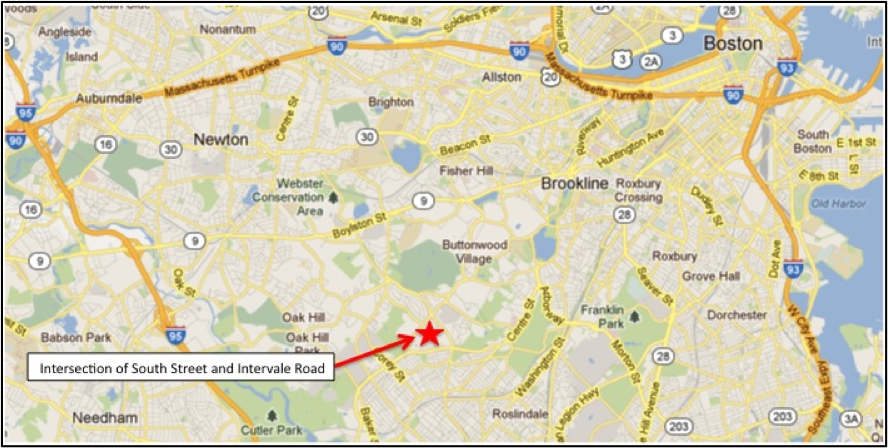
Intersection of South Street and Intervale Road in
Brookline, MA
The implementation of neighborhood traffic circles is
becoming more common in eastern Massachusetts communities in order to create
safer living environments for residents. A traffic-calming circle was recently installed at the
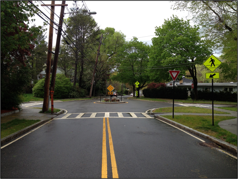
intersection of South Street and Intervale Road in Brookline, MA [FIGURE 7] [FIGURE
8].
FIGURE 7 Brookline, MA Locus Map (http://www.maps.google.com)
FIGURE 8 Intersection of South Street and Intervale Road
This intersection was
previously a conventional 2-lane, 4-leg intersection that experienced high
travel speeds [FIGURE 9].
Massachusetts Department of Transportation crash data displays that
there was an undesirable rate of collisions for a residential neighborhood
at the major adjacent intersections of South Street and Veterans of Foreign
Wars Parkway, and South Street and Grove Street. The implementation of a traffic circle at this midpoint of
South Street was hoped to slow travel speed and increase motorist awareness
along the corridor.
FIGURE 9 Previous Intersection Geometry of South Street and Intervale Road (http://www.maps.google.com)
The neighborhood traffic circle is approximately 10-feet in
diameter with a 1-foot painted shoulder around the outside of the concrete curb
(12-foot outside diameter). The
traffic circle has a 6-foot diameter landscaping area in the center with small
shrubbery that does not inhibit motorists’ sight distance in any way [FIGURE 10]. The concrete curbing has 12
reflective strips around its circumference to increase motorists’ visibility of
the central island at night and four reflective signs that face toward each
main approach direction. The signs
direct motorists to travel in a counterclockwise flow through the use of
directional arrows pointing towards the right.
FIGURE 10 Neighborhood Traffic Circle at South Street and Intervale Road
The traffic circle is visible from all four approaches and
appropriate signage has been placed a few hundred feet before the intersection
in all directions to warn motorists of the intersection treatment they are
about to encounter [FIGURE 11].
FIGURE 11 Traffic Circle Approach Signage
Yield
signs are present along South Street to prompt motorists to ensure the
intersection is safe to traverse before proceeding [FIGURE 12]. Stop
signs have been placed at the intersection along Intervale Road and Grassmere Road, and
require motorists to give priority to vehicles traveling along South
Street. This is due to the presence of higher traffic volumes along South Street. After making the appropriate maneuver (yield or
stop), vehicles wait for a gap in traffic before entering the intersection. The left side of this photo also
illustrates the results of a collision between a vehicle and a utility pole. An old pole has been cut at its base and is now braced against a new pole and supported by a wooden post at the bottom. It
is the hope of the Brookline Transportation Department that collisions such as
this will be prevented in the future as a result of the newly installed
traffic circle.
FIGURE 12 Northbound Approach Along South Street
The pedestrian treatments at the intersection
further display the importance of resident safety in the area. Ladder crosswalks have been placed
along all four crossings of the intersection. This is a type of continental crosswalk marking that is more
visible to approaching motorists than traditional crosswalks. Stop lines have been placed 4 to 5-feet
back from the crosswalks that traverse Intervale Road and Grassmere Road to
ensure pedestrians feel comfortable crossing even when a vehicle is
present at the intersection.
Additional pedestrian crossing signage has been installed at all
pedestrian-to-vehicle conflict points in the intersection to further warn
motorists of a pedestrian presence in the area [FIGURE 13].
FIGURE 13 Pedestrian Accommodations at the Intersection of South Street and Intervale Road
The neighborhood traffic circle currently operates
effectively and successfully processes multiple vehicles concurrently. A site visit displayed that the traffic
circle was able to accommodate a vehicle turning left off of Intervale Road and
a vehicle making a through movement along South Street simultaneously [FIGURE
14].
FIGURE 14 Traffic Circle Processing Two Vehicles Simultaneously
The videos below also illustrate
that vehicles reduce their speed as they approach the intersection and are
required to change their angle as they circulate around the central
island. Vehicles were observed reducing their speed, on average, from approximately 30-35 mph along the South Street approach to 15-20 mph when traveling through the intersection. Vehicles approaching from Intervale Road and Grassmere Road came to a full stop and waited until the intersection was safe before beginning their desired turning movement. This illustrates that the
actual use of the neighborhood traffic circle meets the intended use and
creates a safer residential community.


No comments:
Post a Comment