Sunday, April 25, 2010

Joseph Madrid - Chokers, Westbourne Terrace, Brookline


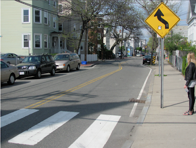
     The purpose of a choker is to narrows both sides of a street.  These parallel curb extensions effectively reduce road widths, which in turn reduce vehicle speeds and make motorists aware of pedestrian activity.  Westbourne Terrace is a street that passes by a school.  The chokers, in this situation is meant to make the drivers aware of school children crossing the road and slow down.  Although, the chokers placed on Wesbourne Terrace have some flaws.
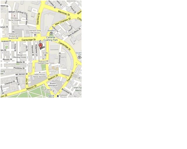
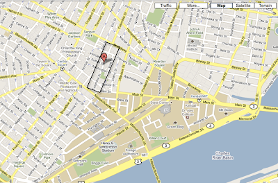
     Westbourne Terrace is a one-way residential street that located in Brookline.   Westbourne Terrace is a local street for Driscoll Elementary School. Driscoll Elementary is a public school serving grades 1st through 8th grade.  Along this street there are houses and apartment buildings along the opposite side of the school.  Westbourne Terrace currently has three chokers spaced 100 feet apart between the school and the residential housing.  Therefore it is important to provide a safe crosswalk for students and residents along this one way street


         As you can see from the first picture this choker has white school crosswalk markings and two yellow walking signs, representing a crosswalk for children and adults, on both sides of the crosswalk.  The signs also have an additional sign below that is stripped yellow and black.   The final touch to this first choker is the monitor that lets the driver know what the speed is at the time of day.  The speed limit when I visited this site was 20 mph.
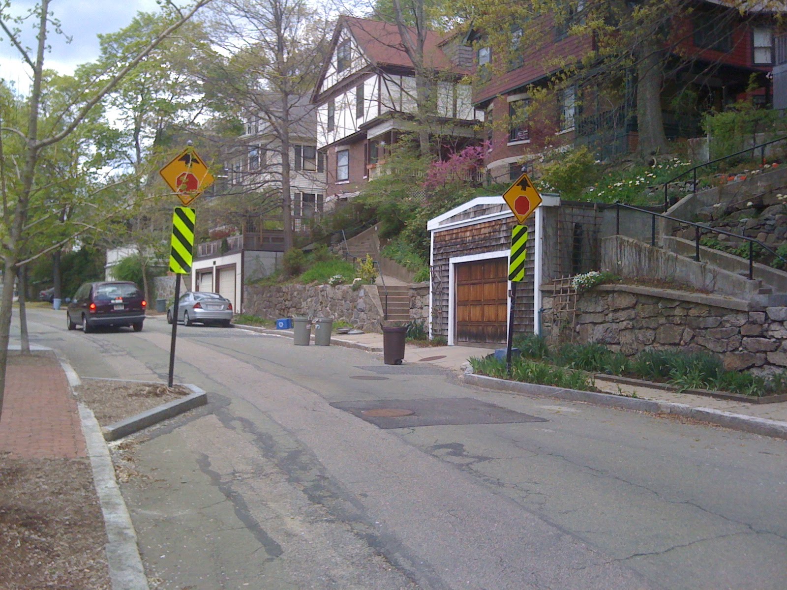
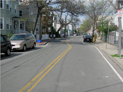
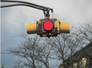
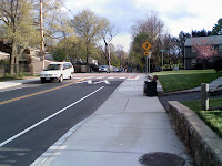
     After this choker there are two more chokers spaced 100 feet down the street.  The second choker, as you can see in the picture, has all the same features but the monitor.  The bright signs definitely get the attention of the drivers.  The last choker is not a crosswalk it is strictly meant to slow traffic down.  This choker has “stop sign ahead” signs as you can see I the picture.  Overall the chokers are placed in specific locations and meant to calm and slow traffic during school hours.  The overall effectiveness is poor in terms of slowing the traffic down because the choker only narrows the road to about 20 feet.  This leaves plenty of room for a car to drive through at a higher speed.  Although the chokers do not force the drivers to slow down it does benefit people crossing the road.  The choker helped the student and residents greatly.  Now the drivers will know if someone is going to use the crosswalk and can slow down to a stop to let them cross.

This is very important due to the high concentration of children when school starts or ends.  A main concern for parents and staff is the safety of their children and students.  With these improvements to Westbourne Terrace, cross-walkers can feel and be safer knowing they can be seen.  One adjustment that can be made is to narrow the road more because Westbourne Terrace is only a one way street and cars only need 10 feet of space to drive through.  This will in-turn shorten the crossing distance and effectively slow cars down.

Saturday, April 24, 2010

Speed Humps on Temple St, Beacon Hill, Boston


Figure 1: Temple St Location
Submitted by Matt Delilla

Temple St is a one-way street with two clear forms of traffic calming in use. The first application of traffic calming is speed humps placed three times along the road. The second application of traffic calming is a nearly 2ft perpendicular movement of the road about 1/3 the way along the street.


Figure 2: Temple St

Temple Street is a high residential road with nearly 3/4 of the street containing apartments. The other 1/4 of the street consists of academic buildings for Suffolk University. Temple Street begins along the low traffic Deme St in the Beacon Hill neighborhood and continues for about 500ft ending at the high traffic Cambridge St. To further enforce that pedestrians come first, parking is not allowed the length of the street on either side.


Figure 3: No automobile but plenty of bicycle parking

First observation noticed about Temple St was the ownership exhibited by the pedestrians and bicyclists along it. The pedestrians walking along the sidewalk did not even notice a vehicle passing by them; some were even walking along the paved street itself. In addition, to the safe feeling expressed by the pedestrians, only 3 vehicles used the road within the 40 minute observation period. All three of these vehicles were cautious along the entire length of the street. The three speed humps did seem to slow the vehicles down a visually significant amount; from about 15 mph to between 5 and 10 mph. The speed humps are placed at strategic places, 1/4 way from the beginning (about 125ft), additionally about 300ft and 425ft from the beginning. This placement does a proper job of calming vehicle traffic and giving precedence to pedestrians.

Figure 4: Speed Hump

In the 175ft gap between the first and second speed humps the road is cut perpendicular to the direction of travel and moved 2-3ft laterally to the right. This separation is strategically lined with red paver bricks, and connects the left sidewalk with a seating area and the right sidewalk. From a personal driver's perspective this feature does a better job of calming traffic when compared to speed humps alone. It makes the road appear narrower than it really is, forcing you to drive slower and better notice your surroundings.


Figure 5: Calm streets for everyone

While these two features combined do a superb job of slowing and calming traffic, one recommendation can still be made. While the speed humps are placed in ideal locations along the length of the street, they are extremely hard to see. If a white or yellow line was painted at the start of the speed hump it might further enforce the calming action and not startle drivers when abruptly crossing them.

Thursday, April 22, 2010

Bicycle Jug-handle - Cambridge, MA

Submitted by Nicole Serafin


The thought of riding a bicycle in the city frightens me beyond belief. I recently brought my bike to the city, and am slowly trying to adjust to riding with city traffic. Although I chose not to ride my bike out to Cambridge, even in a vehicle I was very well aware of the rapport between motorist and cyclist. Cambridge has an entire network of various cycle facilities.

I originally set out to look at the marked bike route between the intersection of Memorial Drive and JFK Street, however there was one particular element that really caught my eye; a bicycle jug handle located at General McArthur Square in Cambridge, MA. This is right before Massachusetts Ave enters the rotary.

Unlike the the traditional jug-handles we think of for cars to make a left turn, the purpose of this on

e for cyclist is to move cyclists from one side of the street to the other when the location of the bike lane changes. This section of the roadway is one way. The bike lane moves to the left side of traffic as roadway approaches the rotary. This allows the cyclist to safely move through the rotary by reducing the number of conflict points between cyclist and merging vehicles.


To use the jug-handle, the cyclist moves to the right, and then loops across the traffic lanes at the cycle cross walk while vehicles are stopped at the light. Once across, you have the option to continue into the bike lane now on the left, or to reverse direction to avoid the rotary all together.


This layout works fairly well in accomplishing its goal of moving cyclists to the other side of vehicular traffic lanes. While I was out on site I did notice one cyclist opt to not use the treatment, however, many more people did us it. If there was going to be criticism to this design it would be that as a cyclist your natural flow to continue with traffic is thrown off, as you have to change directions and wait for the crossing signal. Since the cyclist would have to wait at the light anyways, just now it is for the light in the opposite direction, there is not a huge change in delay. Although this may not seem ideal at first for cyclists, it is a great solution to addressing the cyclist safety. The design is a great example of designing for the entirety of a corridor and not just a single point or location.

Pocket bike lane (between thru lane and RT lane), Galileo Way SB approaching Main St., Cambridge


Submitted By: Liana Afuni

Galilei Way is a multilane, median-separated roadway that intersects with Main Street, in the city of Cambridge, MA . Both these streets are strategic because not only do they serve the Massachusetts Institute of Technology (M.I.T) area, but also they are in close proximity to the “Mass Ave” bridge, which carries Massachusetts Avenue, from Back Bay, Boston to Cambridge, MA, and is the longest bridge over the Charles River.


Locus of Area

On the southbound approach of Galileo way, the bicycle lane is located alongside the curb until it nears the intersection at Main Street, for which a traffic calming measure is implemented.  In order to maintain safety for bicyclists, consideration needs to be taken in regards to vehicular right turns being allowed off of Galileo Way. There needs to be a transition from the thru lane in order to allow right-turning vehicles to merge. Since there is adequate curb to curb width, the bicycle lane is dotted approximately 20 ft from the stopline, The key is for the dotted stripping not to occur too far back from the stop line, because then vehicles would have enough room to accelerate at high speeds within the right turning lane, which could compromise the safety of the cyclists. This approach results in a “pocketed” bicycle lane, in between two travel lanes.


 Galilei Southbound Approach

One would argue that the merging stage would be unsafe for the bicyclists since vehicles have to maneuver into the right turn lane. But the question is, who has the right of way? After having researched online, an anonymous blogger, who is clearly a cyclist expressed that, “I tend to give the car the right of way because I assume everyone in a car wants to kill me.” In this particular case, the right of way is not unambiguous, because the blue paint delineates the separation. However, I would recommend that the right of way be clarified further at this intersection by perhaps a warning sign, placed a couple of feet ahead of the dotted lines, that gives the right of way to the cyclists. According to AASHTO, a recommended configuration for bike lanes with right turning traffic is identical to that located at Galilei Street. 


To further ensure the safety of the cyclists at the merge intersection, blue paint is used to illuminate the merging right turn lane. This color treatment has been used for a "test trial" in only two cities in the U.S, Cambridge and Portland. Galilei happens to be one of the streets that utilizes a change in pavement coloring. This kind of treatment helps in establishing a right of way for cyclists in such cases. The results of the added blue paint in several cities have reached such conclusions as:

  • Significantly more motorists yielded to bicyclists and slowed or stopped before entering the blue pavement area;
  • More bicyclists followed the colored bike lane path.
  • Fewer bicyclists turned their heads to scan for traffic or used hand signals, perhaps signifying an increased comfort level or lower level of caution.

The benefit of having a bicycle lane “pocketed” in between a thru and right turning lane, is this prevents the “right hook” problem that cyclists can face. The right hook occurs when a car passes a cyclist and then tries to make a right turn directly in front of or into the cyclist. Vehicles don’t assume that cyclists are going very fast, so it never occurs to them that they can pass the cyclist in time. However, with the right turning lane being placed by the curb, and a prior merge dotting, vehicles will no longer turn in front of the bicyclist, which eliminates this collision.


Demonstrating a "Right Hook"

Another important factor of a bicycle lane, especially if pocketed, would be the width of the lane. The striped off pocketed lane is approximately 6 ft, which is enough space for a cyclist to ride comfortably. Furthermore, since the curb is brought back in closer to the landscape medians, there is more than enough space to fit in a right thru lane without compromising the widths of the remaining travel lanes and bicycle lane. So although the cyclist will be in between traffic, it is not for a long portion of the trip, neither is the cyclist lane jeopardizing the safety of the rider.

In essence, "a pocketed bike lane" is the perfect traffic calming measure for both cyclists and vehicles, especially with a clearly defined merge lane that leaves no room for ambiguity. 


Chicanes on Columbia Street, Cambridge


Submitted By Mahmoud El Hazek


Columbia Street is a two-way local roadway that intersects Massachusetts Avenue in the city of Cambridge, Massachusetts. The roadway is a north-south route that cuts through a residential neighborhood that is primarily occupied with houses, and a public playground and park for the younger residents and teenagers in the area. The roadway contains one 11 ft travel lane in each direction, with parking space on the east side of the corridor until Washington Street intersection. The city of Cambridge has implemented two chicanes along Columbia Street between Washington Street and Worcester Street, which are spaced at approximately 225 ft apart. By definition chicanes are curb extensions that alternate from one side of the street to other forming s-shaped curves. The chicane effect on Columbia St. is achieved by shifting the parking space between the east and west side so that drivers need to turn between the shifting parked vehicles.

One key feature of the chicane treatments along Columbia Street is the signage. Before every chicane, a sign is placed to alert drivers that the turns exist so that hopefully they would slow their speed if necessary. The signs are placed in both directions so that vehicles travelling northbound and southbound are exposed to the sign before they hit the chicane.

The chicane on Columbia St. is designed and intended to act as a traffic calming measure that will reduce vehicular speeds, or ensure that the speeds are not exceeding the 30mph limit. More specifically, drivers are intended to reducetheir speed in order to safely turn in both directions while remaining in their correct travel lane. Drivers that are driving too fast may face difficulty turning and can either collide with the parked vehicles on Columbia Street or not be able to recover from a turn and may engage in a head on collision with opposing vehicles that may ‘surprise’ them. The fact that these chicanes were implemented may suggest that residents/city were frightened from high speeds in this highly residential corridor. Other emphasis on this treatment could be:

  • To reduce speeds close to the public playground as children are usually walking to and from their homes to access this facility
  • To ensure safety of pedestrians walking near the roadway
  • To reduce speeds in order to allow for drivers to stop or react incase of a parked driver opening their door suddenly – the narrow roads does not provide any ‘dooring’ space between travelling and parked vehicles

The chicane treatment may be beneficial, however is not needed along Columbia Street. Firstly it is important to note that along the first intersection when travelling right from Mass Ave there is a flashing red light, which forces drivers to come to a complete stop and may proceed only if there are no conflicting traffic or pedestrians. This light is in fact not needed as at that same intersection there is a stop sign, which essentially will force vehicles to completely stop as well. With this light, vehicular speeds are calmed and there isn’t enough time and distance for vehicles to pick up speed to the next intersection, as a flashing yellow light is placed at the right before the first chicane just after Washington Street and Columbia Street. These collective measures enforce vehicles to enter the chicane turns at relatively low speeds (approximately witnessed at 20mph) in the first place. Although it is arguable that the chicane ensures that the speeds are kept low, I believe with the excessive signage and flashing lights for awareness already existing a cheaper solution could have been implemented, like speed humps.

The design objective is also not met as drivers witnessed on Columbia Street tend to encroach on the opposing lane while driving along the chicane, so that they maintain a straight-line path across the centerline without needing to slow down. This is possible as while out on the field it was witnessed that two cars crossing the chicane in the opposing directions at the same time was very rare (I witnessed this event twice or three times only), and so drivers had the freedom to encroach without any fear of collisions for most of the time.


This design could be possibly improved by making reverse curves sharper and longer. It is clear that the chicane curves on Columbia Street are wide enough to defeat its purpose of slowing down the traffic. Another alternative design or adjustment to the chicane is the implementation of a raised median that may prevent the current problem of drivers encroaching on the centerline. However to implement this impeller concept, parking may be eliminated to provide space for the median. Furthermore, as stated earlier the calming design used could be exchanged for a cheaper one that would maintain lower speeds in the residential community, especially since chicanes are expensive due to the high costs of curb realignment and right of way. Two speed humps spaced 200 feet apart will reduce speeds along the corridor in this case as well as two chicanes spaced 200 feet apart and which have low compliance from drivers. Initially the corridor has a stop sign placed at the preceding intersection, flashing yellow and red lights, and raised crosswalks, and narrow lanes that all ensure approach speeds into the chicane are much less than 30mph, which further reinforces the unnecessary need of a chicane treatment in this investigated area.

The traffic is already calm throughout, I believe that the calming treatments are over implemented on that stretch of the corridor. A video attached additionally shows that vehicles are of relatively low speeds before approaching the chicane already which raises questions of the necessity of an expensive measure over other treatments that may maintain the ALREADY calm traffic in the neighborhood.


Blanchard Road, Belmont/Cambridge, Massachusetts

Submitted by Paul Carbone


Blanchard Road, which lies on the border of the city of Cambridge and the town of Belmont, is located just west of Fresh Pond and crosses Concord Avenue. Recently Blanchard Road was redesigned to slow down traffic and accommodate bicycles, while still allowing for MBTA buses and a large volume of traffic to use the road.

Blanchard Road was originally intended to be a local road but it has become a popular shortcut route between Belmont and Watertown, and is now more of a collector. Speeds on Blanchard Road were sometimes higher than is suitable for the densely populated residential area that is present on the road. In addition this area has become an increasingly popular place for recreation, especially for bicyclists, with many nearby paths. Local residents also use bicycles to commute to the Alewife MBTA station, which is less than a mile away from Blanchard Road. Additionally, the road is along the route of the 78 and 74 buses from Harvard station. The combination of high speeds and volumes in a residential area and heavy bicycle traffic meant that Blanchard Road was in need of a redesign. There was a need to slow down traffic, while also providing a facility where vehicles would be more mindful of bicyclists and buses could still be accommodated. Within the last year Blanchard Road was revamped with bike lanes or sharrows as well as many traffic calming devices to try and address these needs.

Blanchard Street to the North side of Concord Avenue contains two new major features: a chicane and sharrows along the edge of the road.


The chicane was created by adding a grass bumpout at the intersection of Blanchard Street and S. Normandy Avenue. Signs are posted advising a 25 mph speed through this area. During a short observation of the chicane, it was found to be effective in the immediate area during times when there were vehicles travelling in both directions or vehicles travelling at exceptionally high speeds for this road. However, when there was no opposing traffic, vehicles would encroach over the centerline to maintain speed. In addition, vehicles that did slow down typically sped up shortly after the chicane. Additionally, there is a crosswalk at the location of the chicane and it seems that a median refuge would have been a better use of the extra space that the chicane uses. To more effectively slow traffic down, additional traffic calming devices would be needed.

Blanchard Street in this area is too narrow for dedicated bike lanes, so sharrows were utilized. The sharrows provide experienced bicyclists with recognition but they are not a great option for inexperienced riders, especially with the chicane. However, there is not much room for any other option and sharrows are better than not acknowledging bicycles. Since the northern part of Blanchard Road was completed before the Southern section, the one improvement that is needed is a repainting of the sharrow symbols in the lanes to make them less faded.

To the South side of Concord Ave, Blanchard Street incorporates many new features: small chicanes, a raised intersection/ crosswalk, in-street reflectors, a modern day roundabout, and dedicated bike lanes.


First, just south of Concord Ave there is a small chicane created by shifting the sidewalk widths on both sides of the road. This chicane does not have a huge effect on speed but coupled with the other traffic calming devices, it helps to lower the travel speeds overall.

Also starting just south of the intersection of Blanchard Road and Concord Ave are two one-way bike lanes on the outside of the travel lanes. These bike lanes are a much safer alternative to sharrows and they provide access to Concord Ave, where additional bicycle facilities are present.

A few hundred feet farther down the road there is a raised intersection with an advisory speed of 20 mph. Approaching the intersection there are yield markings and the entire raised intersection is composed of red pavers. This measure appeared to be very effective at slowing down vehicles on Blanchard Road and it also serves as a crosswalk for pedestrians. The design is also easy to travel on for bicycles.


Along the length of the southern portion of Blanchard Road there are in-street reflectors. These reflectors are located along the centerline and between the vehicular lanes and bike lanes. They enhance the visual separation between bicycles and cars as well as opposing lanes. The reflectors also allow the separation to be more visible at night.


Farther down the road, there is a sharp curve. While this was not added, the curve serves as a traffic calming device. Curve signs together with narrower lanes make this an effective way to maintain the slower speeds that the raised intersection brought vehicles to.


Finally, there is a modern day roundabout immediately following the curve. This greatly helps to slow down traffic. The radius of the roundabout is small, but it is large enough for buses to navigate. Approaching the roundabout there is a crosswalk with a median divider that cuts the crosswalk in half. This provides much more protection for pedestrians that need to cross the road. The only area that arose concern was that the bike lanes ended and sharrows were used instead for the roundabout. This roundabout experiences heavy traffic and after providing the increased safety of dedicated bike lanes, it would be ideal to provide a more exclusive bike route through the roundabout.

A local resident waiting at the bus stop was very supportive of the changes that were made on Blanchard Road, and he said that they have made a huge difference in the speed of vehicles traveling on this road. He also said that riding a bicycle feels much safer with the dedicated lanes Individually the improvements may not have been completely effective but as a whole they have done a great job of meeting the needs of the residents.

Sharrows at gap in Washington Street - Belgrade Ave bike route

Belgrade Ave and Washington Street are both major streete in Roslindale and run towards each other as they approach Roslindale Square. Connecting the two routes are South Street and Corinth Street, both one way. These streets border Roslindale Square and its many shops and businesses. On a typical day, Roslindale Square is full of many pedestrians and vehicles who travel to the area to reach various destinations that range from the Villave market to Wallpaper City. Another user that had recently been introduced to the area is cyclists. Along Belgrade Ave a bike lane has been intergrated in the roadway that spans 0.93 miles. Washington St has also incorporated a bike lane that spans 1.29 miles throughout Roslindale.


These pictures show the typical bike lanes along Belgrade Ave (above) and Washington St (below) to the right side of the roadway.


As Belgrade Ave and Washington St advance toward Roslindale Square, these bike lanes are replaced with sharrows in the travel lanes. Pavement markings are indicated on the roadway to show the transition on the street. Sharrows signify that the travel lan is now shared with vehicles and bucycles. These sections of the road connecting Washington St and Belgrade Ave are too narrow for the bike lanes to continue due to the on street parking on both sides of the street and the narrow lanes.


These pavement markings are located in the center of the travel lane. Coming off of Belgrade Ave, the bike lane continues until the first crosswalk and then the sharrows transition to a shared lane. Although these markings are indicated on the roadway, a lack of proper signage is evident throughout the corridor. At the transition, the only sign visible to drivers and cyclists is the "Form Two Lanes" sign on both sides of the road. The on street parking on both sides of Corinth St and South St make a shared lane more appealing to cyclists in order to avoid collision with opening doors.


The sharrows are designated on both travel lanes due to the close proximity of the intersection of Washington St where high volumes of traffic was observed to continue toward both directions of the street.


From Corinth St traveling north on Washington St, bike lanes continue along Washington St. The same treatment is seen as South St approaches Belgrade Ave.


The City of Boston has incorporated these bike routes in the city's bike map which indicated that the bike facility on Belgrade Ave is for intermediate cyclists while Washington St favors more advanced cyclists. These bike routes to the center of Roslindale do not accommodate the needs of beginner cyclists due to the high volumes of traffic as well as the various obstacles a cyclist may encounter. Continuing the bike routes within these gaps will require reallocating the curb to curb width of the roadway and possibly eliminating on side of parking. Currently, the City of Boston as well as the residents of Roslindale are considering alternatives for developing a bike lane for these streets to connect the Washington St - Belgrade Ave bike route in the future.
Road closure, Lafayette Square (Main St / Columbia St / Mass Ave), Cambridge

Submited by Jennie

Lafayette Square, the intersection of Main Street, Columbia Street, and Mass Ave, has been transformed into a redesigned intersection and pedestrian plaza due to its complicated driveway. Lafayette Square is located along Massachusetts Ave, Sidney Street and Main Street. Massachusetts Ave is an article of two-way, four-lane and two way cycling roadway. It crosses with Sidney Street and Main Street which is implemented road closure now. Main Street and Sidney Street is a local street which is a two-way. Columbia Street is a two-way two lanes road.

Before the construction, road closure, had started, it exists four intersections around Lafayette Square. Vehicles from Main Street to the intersection of Main Street and Mass Ave need to pass two closed intersections, Main Street and Columbia Street, and Main Street and Sidney Street.
The complicated geometric structure of the roads is easy to result in some impacts:
  • Many movement conflicts located in so short distance are easy to increase incidents.
  • People who drive on Main Street run through Lafayette Square to Mass Ave are easy to ignore the cross road and forget to slow down their speed.
  • People need to wait two traffic lights. It could be easy to result in drivers spend more time to wait and loss their patient.
  • The closed signalized intersections are easy to result redundant lost time and worsen service level.

Therefore, the City of Cambridge planed to redesign the roadway and close Main Street form the intersection of Main Street and Columbia Street to the intersection of Main Street and Mass Ave. The construction started in early 2005, and was completed in summer 2008. The construction is to implement road closure from intersection of Main Street, Columbia Street, to the intersection of Main Street and Mass Ave, and reconstruct the roadway and new sidewalks. The project used bollards and gateway pier to close the road.
From Main Street to Mass Avenue or from Columbia Street to Mass Avenue, drivers have to make a detour by Sidney Street. The construction also supplies pedestrians and bicyclists a safety space to access. Main feature of the construction is to provide the roadway service and improve safety of the corridor for pedestrians, bicyclists, and vehicles. They also set some chairs and tables to supply people a leisure place.


The road closure of Lafayette Square has the following features:
  • Make the intersection easy for all modes to use.
  • Improve accessibility and safety for cyclists and pedestrians.
  • Create a new community plaza.
  • Minimize impacts on parking and loading.

The construction also brings some problem about traffic signal and roadway that would have to be continued to take care. The old traffic lights and land marking do not remove from Mass Ave that will confuse drivers’ follow. The marking on the roadway from Columbia Street to Main Street doesn’t use the standard frame. It is a low visibility marking for user to follow.


In summary, this project achieves its goal to improve and provide a safer environment for vehicles, cyclists and pedestrians by road closure. The construction is not only focus on traffic safety but create a new community plaza. Although it will make people have to make a detour from Main Street and Columbia Street to Mass Ave it reduce traffic confliction in this area that is the best objective for a traffic engineering designer.